5 ha plot near Șimleu Silvaniei Industrial Area
Industry
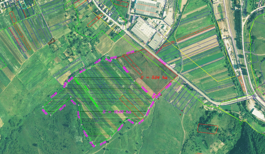
5 ha plot of land located in Șimleu Silvaniei, Sălaj County. The plot is situated near the Industrial Area. At the moment, the land is partially located inside/outside the urban land. The building code could be updated depending on the requirements.
General
Address
455300 Șimleu Silvaniei, Cehei street
County
Sălaj
Territorial and Administrative Division
Șimleu Silvaniei
Property availability
The land is available. It is worth mentioning that the local administration will have a proactive approach in supporting the steps necessary for the implementation of the project.
Legal Owner
Șimleu Silvaniei City Hall
Proposed Contract Type
Sale
Estimated Price (€/mp)
4-6 EUR/ sqm
Prior and Current Legal Disputes
Not the case
Method of taking possession
Direct Assignment
Additional Information
https://maps.app.goo.gl/hEW5kDmfUqUBnp4H6
Property Details
Land area (m²)
50000
Land Type
Hybrid
Classification lv. 1
Urban
Classification lv. 2
Industrial
GPS Coordinates
455300 Șimleu Silvaniei, Cehei street
Land Shape
Rectangular
Street Frontage (meters)
243
Neighboring Properties
North: DJ108F; East: private properties, West: Șimleu Silvaniei, South: private properties, with a possible extension of 15 ha.
Utilities
Electrical Voltage
Mixed variants available
Maximum Electrical Capacity
The current capacity can be scaled up to 3 MW
Position in Relation to the Nearest Electricity Source
200m
Maximum Gas Pressure (Nm³/h)
1600
Position in Relation to the Nearest Gas Source
At the property limit
Maximum Potable Water Pressure (m³/h)
22
Position in Relation to the Nearest Potable Water Source
At the property limit
Wastewater Disposal (m³/h)
Available
Position in Relation to the Sewerage Network
At the property limit
Type and Strength of GSM Signal (1-5G)
4G, 4G+
Type and Speed of Internet (Fiber Optic, Cable, Mbps)
Optic fiber, 1000 Mbps
Large Infrastructure
Position in Relation to Major Cities or Municipalities (km)
108 km - Cluj Napoca, 88km - Oradea.
Position in Relation to Nearest European Roads (km)
14 km - E 81
Position in Relation to Nearest Highway (km)
The entrance/exit point of the Transylvania Highway is located 27 km away, on a section currently under construction, which is just 8 km away.
Position in Relation to Nearest Border Crossings (km)
80 km - Petea Border Crossing
Position in Relation to Nearest Seaports (km)
712 km - Constanța seaport
Position in Relation to Nearest International Airports (km)
91 km - Oradea International Airport
Position relative to the nearest passenger and/or freight railway station (km)
2.5 km - Șimleu Silvaniei train station
Accessibility
Accessibility by Public Transportation
Available
Accessibility for Large Trucks
Available
Access Restrictions
Not the case
Possibility of Natural Disasters
Not the case
Development Regulations
Built Area, Height or Structural Restrictions
At this moment, the land is partially outside / inside the build-up area of the town, it results that a zonal urban planning documentation is needed. Through this documentation, with the specific industrial function, the construction norm can be updated, according to the needs.
Subterranean, Overhead, or Airspace Obstructions
Not the case
Environmental Restrictions
According to the regulations and laws in force
Investment Opportunity
What are the advantages and benefits offered to the investor?
The land is located near the industrial area. In the future, the area will be included as an industrial park. The whole area (as well as the whole city) is in a continuous development. Our city serves an area of approx. 35% of the county, this translates into approx. 60,000 people. Therefore, the labor force is within a limited range of approx. 20 km. As facilities granted to investors by local authorities (in addition to national ones), they can be: exemptions from taxes and fees, mediation and bringing the utilities to the needs of the investor. As before, the local authority is in close contact with the private sector, always having a proactive approach in solving any problems or needs.